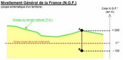
Elevation defined either in NGF level (French levelling network) or in relative depth. The NGF level, established under the control of the National Geographic Institute (IGN), is the reference. NGF can indeed express altitudes in one and unique reference system, i.e. as compared to the same and unique fundamental point (or "origin-zero" or point zero). The "0" level is the average sea level in Marseilles. This point is used to determine the altitude of any other point. The elevation of the piezometric record can also be expressed in relative depth with respect to the benchmark of the water point. Each water point has indeed two main remarkable points: the benchmark of the water point (measurement benchmark as compared to the level of the groundwater at the water point - edge of the well casing, edge of a well, pontoon on a gravel pit, etc) and elevation references, which allow comparing measurements obtained at several water points to determine the status of the groundwater over the entire surface (three locations can be used as elevation reference : the upper lip of the base (edge), the soil around the water point (ground) or direct measurement benchmark - edge of the tube).